GreenX Metals Limited (ASX:GRX, LSE:GRX, GPW:GRX) (GreenX or Company) is pleased to announce significant results from its Tannenberg Copper Project (Tannenberg or Project) in Germany, with new geophysical data identifying that the likely deep source of copper mineralisation beneath one of Europe’s most prolific historic mining districts is present under the Tannenberg licence area.
HIGHLIGHTS
- Successful completion of 58km2 airborne magnetic and radiometric survey over the Tannenberg Project in Germany, covering the brownfields Richelsdorf copper district, which produced 416,500 tonnes of copper at grades of between 0.8 and 1.2%* (1800s to 1950s)
- Major geological insight gained with identification of deep metal source structures directly below the historic Richelsdorf mines, following the first modern exploration in 40 years.
- Mid-European Crystalline Zone (MECZ) identified beneath the Richelsdorf mining district – the same geological structure understood to be the primary source of copper in the Kupferschiefer deposits across the European Copperbelt in Germany and Poland
- Large-scale anomalies extend beyond survey area into the Tannenberg 2 licence, significantly increasing exploration potential
- Comprehensive exploration program integrating geophysical results with core relogging, geological modelling and historical data to guide next phase of exploration
- BHP Xplor funded 100% of survey with geological concept build-out and exploration timeframe being expedited in collaboration with BHP
The recently completed airborne magnetic and radiometric survey represents the first major exploration work at Tannenberg in four decades. Combined with reprocessed gravity data, these results have revealed large-scale geological structures directly below the historic Richelsdorf copper mines, providing crucial insights into the source of mineralisation that produced 416,500 tonnes of copper from these historic mining operations.
Most significantly, the survey has identified the presence of the Mid-European Crystalline Zone (MECZ) beneath the mining district. This geological structure is considered the primary source of copper for all major deposits along the European copper belt spanning Germany and Poland. The presence of this same structure beneath Tannenberg provides a strong geological rationale for the potential of significant copper mineralisation (referred to as “Kupferschiefer”) in the project area and supports extensive further exploration.
GreenX CEO, Mr Ben Stoikovich, commented: “After 40 years without modern exploration, we have identified several previously unknown geological features below the historic Richelsdorf mines that will form a fundamental part of our understanding of the mineral system. Our historic archive review is progressing at pace, and with the combined interpretation of the geophysics results, continues to contribute to our confidence in the value of this project. With our expanded 1,900 km2 licence package, we have a large, relatively shallow and potentially high-grade copper brownfields exploration project, with copper being of a highly strategic commodity for both Germany and the EU.”
AIRBORNE GEOPHYSICAL SURVEY
Survey Area
The 58km2 airborne survey area (Figure 1) was flown using a helicopter-mounted magnetic and radiometric system, covering 660 line-kilometres with high-resolution data collection at 100-metre line spacing.
Advanced processing techniques, including analytic signal, tilt derivative and reduced-to-pole transforms, were applied to extract maximum geological information from the dataset.
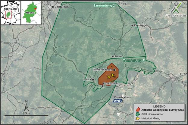
Figure 1: Expanded Tannenberg Project Area with historical mine workings, showing the airborne geophysical survey area and historical underground workings.
Key Findings
The magnetic data shows two large amplitude anomalies, which have been interpreted alongside recent magnetic susceptibility measurements from drill core. The only explanations for the anomalies are deep volcanic rocks within an uplifted basement block deep below the historic mines. Consistent with the magnetic data, the reprocessed residual gravity data shows a northeast-southwest striking residual gravity high which is interpreted as an uplifted basement block. These magnetic and gravity anomalies lead to the conclusion that the MECZ underlies the historic mines.
The MECZ is a belt of very old rocks that runs across central Germany and into Western Poland (Figure 2). These rocks include ancient granites, volcanic rocks, and sediments that were later changed by metamorphism during a mountain-building event called the Variscan orogeny about 300 million years ago. Today, the zone can be seen at surface in areas like the Odenwald (south of Frankfurt), while in other places like the Tannenberg project it is buried under much younger sediments. When a mineral deposit is formed, a source of metals is required through which fluids move to scavenge the copper, these fluids then redeposit the metals higher up within sedimentary rocks.
The consensus in European Kupferschiefer research is that the MECZ of the basement as well as intra-basinal volcanic rocks are the source and as such have contributed the copper and other metals to these mineral deposits (Rentzsch & Franzke 1997, Borg et al. 2012).
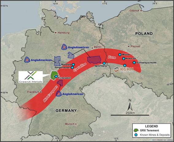
Figure 2: Extent and location of the wider Mid-European Crystalline Zone (schematic) in Germany and Poland (after Bankwitz 1994) in relation to the locations of key historical and currently operating mines, mineral deposits, and tenements.
While the major geophysical anomalies identify the source of the copper, other patterns in the magnetic data can be explained by faulting that could have provided pathways for the upwards movement of the metal bearing fluids that formed the mineral deposits. These anomalies and faults are hidden below the deepest drilling data so far known and represent an important advancement in the understanding of the deep geological and structural architecture and gives important guidance of how new mineral deposits can be found.
The anomalies and faults extend well out of the boundaries of the survey area and towards the east into and beyond Tannenberg 1 and towards both the north and southwest into the new and larger Tannenberg 2 licence area (Figure 3 and Figure 4). Not only do these results highlight the prospectivity of the wider Tannenberg licence package, but they show that deep-reaching, low-impact and low-cost exploration methods such as ground gravity and airborne magnetic surveys can contribute considerably to the discovery of new mineralisation and ore deposits.
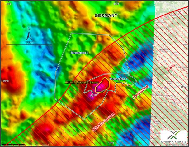
Figure 3: Residual gravity anomaly within the Tannenberg 1 and Tannenberg 2 licences. Showing the gravity high (red) feature interpreted as Mid-European Crystalline Zone.
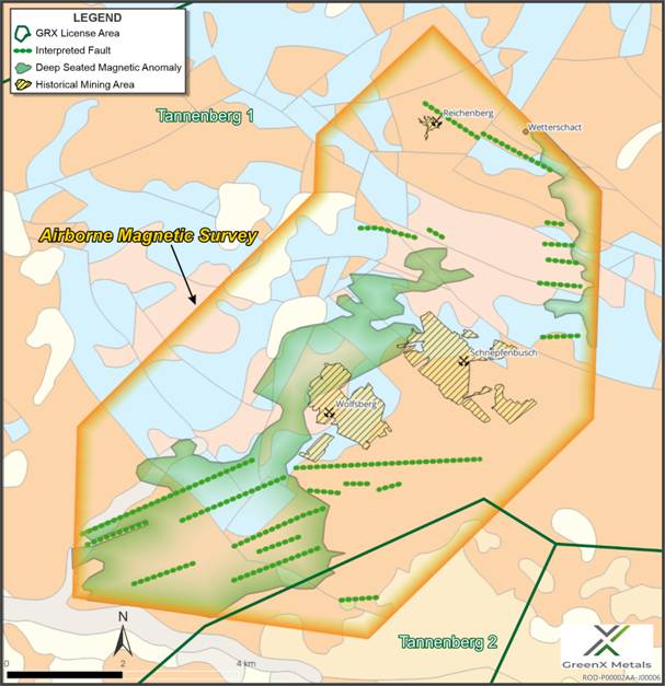
Figure 4: Location of the magnetic anomaly associated with deep-seated geological structures (green) seen at depth below and adjacent to the Tannenberg historic mining areas. The image also shows the proximity to historic mines and related outcropping geology as well as fault structures. The helicopter surveyed the area by flying between north and south along lines 100m apart.
SURVEY METHODOLOGY
The airborne magnetic survey was conducted by Terratec Geophysical Services GmbH & Co KG between 19 and 22 May 2025 and comprised 660 line-kilometres of total field magnetic and radiometric data collection, flown at 100-metre line spacing with 1,000-metre tie-lines. A helicopter-mounted Scintrex Cs-I magnetometer and MEDUSA radiometric system were used in a nose-boom configuration to minimise noise and improve resolution. The survey area was designed to be a test over known historic mining other areas with exploration potential (Figure 4).
Data processing included magnetic compensation, diurnal and IGRF corrections, tie-line levelling, and advanced filtering (including analytic signal, tilt derivative and reduced-to-pole transforms). Radiometric datasets were fully calibrated, with potassium, uranium, thorium and total count grids produced.
In relation to the reprocessed gravity data, the input data originated from the Hessen State Bouguer anomaly dataset and was prepared by the Hessian State Agency for Nature Conservation, Environment and Geology (Hessisches Landesamt für Naturschutz, Umwelt und Geologie) in collaboration with Leibniz-Institut für Angewandte Geophysik (LIAG, Hannover). Gravity readings were collected at ground stations on a regular grid across the region, with precise elevation control from differential GPS to allow correction for latitude, elevation, and terrain effects. Subsequent residual gravity processing removed the broad, long-wavelength regional signal from Bouguer gravity data in order to isolate shorter-wavelength anomalies caused by local geological features. This has allowed Company geologists to more clearly identify the features directly related to mineralisation.
UPCOMING WORK PROGRAMS
The geophysical survey is part of a larger exploration work program planned in collaboration with and funded by the BHP Xplor program, which has been extended to 31 October 2025. Key features of GreenX’s 2025 exploration program at Tannenberg include:
· Logging, assaying, and hyperspectral scanning of historical core;
· Reprocessing and analysis of historical geophysical data; and
· Collation of historic exploration, mining and production data.
Following the highly successful trial aeromagnetic survey, the Company also is investigating possible additional data collection.
ENQUIRIES
|
Ben Stoikovich Chief Executive Officer
+44 207 478 3900 |